Kuvatakse päringule landscape vastavad postitused asjakohasuse alusel. Sortimine kuupäeva alusel Vaadake kõiki postitusi
Kuvatakse päringule landscape vastavad postitused asjakohasuse alusel. Sortimine kuupäeva alusel Vaadake kõiki postitusi
Paper: POST-STRIPPING PROCESSES AND THE LANDSCAPE OF MINED AREAS IN ESTONIAN OIL SHALE OPEN CASTS
1.1 POST-STRIPPING PROCESSES AND THE LANDSCAPE OF MINED AREAS IN ESTONIAN OIL SHALE OPEN CASTS [SLIDES] I. VALGMA The present study describes creating a digital map of oil shale surface mining technology and evaluating mining influences on the landscape. The data from the digital map of the Sirgala open cast show a constant increase in the overburden thickness. Overburden material thickness influences directly the future landscape but it also sets limits to stripping equipment parameters and productivity. The present open cast landscape was divided into four classes: afforested area, area with poor vegetation, graded area, and spoils. The second purpose of the study is saving information in an easily accessible form for the future. For this purpose geographic information system for mining is used. Introduction The minerals of Estonia are excavated in the amount of 10.5 million m3 per year. Yearly 7.4 million m3 of oil shale is mined, and half of this is mined in the open cast mines. The total surface mining amount in Estonia is 6.7 million m3 per year, and 54 % of it stands for oil shale mining. From this data a general rule follows: 1/3 of the volume of mined minerals comes from oil shale underground mining, 1/3 from oil shale surface mining, and 1/3 from surface mining of other minerals. Mining areas could be divided into five reclamation categories. First - mud excavation area - where mining takes place under water, is no subject for reclamation. Second - clay mining pits - are reclaimed to water storages, ponds or landfills. Third - sand and gravel quarries - are graded or formed as ponds. Fourth - limestone and dolostone quarries - form relatively deep ponds or are filled with waste. Among small-scale mining their reclamation is the most problematical one. Fifth - oil shale, phosphate rock and peat mining areas - are large due to thin horizontal bedding and require special reclamation. The largest Estonian surface mines are described as an example of large-scale mining operations and post-stripping processes. These open cast mines are largest by both area and production capacity and so cause also the largest influence to the environment and landscape. These three are the Aidu, Sirgala and Narva oil shale open casts, situating in the deposit wings where overburden thickness is smallest (Fig. 1). On the whole 120 km2 of overburden have been stripped in these mines. Fig. 1. Estonian oil shale deposit Calculations and charts in the present paper describe mostly the Sirgala open cast as the largest open cast mine in Estonia. Detailed description of the past processes in the mined-out areas let us understand, predict and save the information about several technological and environmental influences. Many of processes explain the reasons of forming the present landscape in these areas. The data about the equipment can help planning next trenches working in similar conditions. The data about steps of technological development of surface mining help us to retain historical data about large mineral extraction areas. A geographically referenced database represents a most suitable tool to study all these problems. Methods Geographic information system (GIS) for mining is used for describing and analysing spatial mining-related data. GIS is used for describing, in addition to technological problems, also post-technological processes. The main result is a digital map illustrating the oil shale mining technology. The present study presents the second stage of the map creation at the Mining Institute of Tallinn Technical University. During the first stage underground mining technology was mapped, the second stage includes the map of surface oil shale mining [1, 2]. Information on the map was taken from the technological maps of oil shale open casts, geological investigations, and aerial photographs and from the digital Estonian base map. Fig. 2. Mining sections in the Sirgala open cast The study included the following steps: collecting maps and references about the area, scanning, digitising and vectorising map data. The contours of the blocks mined in every mine section during a year were extracted and mapped. The database includes, in addition, the year of mining, height of the ground above the sea level and overburden thickness. As the result a digital surface mining map was created. The map (Fig. 2) includes stripping data and also aerial photographs and represents a basis for studying stripping dynamics, areas, volumes and landscape situation. Discussion Mapping calculations show that the total area of the mined sections in the Sirgala open cast is 6,532 ha. Aerial photographs from the year 1996 cover all the area except section No. 4[*]. Therefore in examples section No. 4 is excluded. The total production capacity of all Estonian oil shale open casts is 3 million m3 or 5 million tonnes of oil shale per year. Every mine produces, on average, 1 million m3 of oil shale per year. Oil shale yield is 3.4 tonnes per m2 of mined area; therefore, the total area of surface mining movement is 1.5 million m2 per year. As could be seen from the chart of the mined areas in the Sirgala open cast throughout its history (Fig. 3), its total annual movement area is 1 million m2. In the case of average rates the area should be around 0.5 million m2. In reality Sirgala’s load is 44 per cent of all open casts. This situation reflects either an overestimated yield of oil shale or oil shale overproduction. Figure 3 Stripping areas of Sirgala open cast from 1949 to 1999, thousands m2 per year Taking 80 m per year for an average shift of the mine face, the total length of operating sections is 20 km. On average, every open cast has a 6.5-km mining front, four mining sections with the length of 1.6 km and four haulage trenches. The width of the mining and haulage trenches varies from 25 to 55 m. The total height of the spoil forms after stripping and reclamation. Mined out oil shale bed with a thickness from 2.5 to 3 m also decreases the final height of the spoil by its thickness. Blasted overburden that consists of lime- and dolostone with clay requires 1.4 times more space than in the bank. The average loosening coefficient of quaternary sediments such as sand, peat, clay and moraine is 1.2. It means that the final height of the spoil surface in the Aidu open cast (see Fig. 1), where the total overburden thickness is 17 and the soft part of it 3 m, will be 4 m higher than the ground surface. In the Sirgala open cast the raise will be 4 m and in the Narva open cast 6 m. The height of the spoils of the overburden material is 3 m higher beside haulage trenches because of the additional material from the trench. The relative change in the surface height in other Estonian surface oil shale mines does not exceed 1 m. These mines are Kohtla, Kohtla-Vanaküla and northern section No. 4 of the Narva open cast. Possible surface mines like Tammiku-Kose, Sonda, Ubja and partly Aidu section No. 2 have the same parameters. For example, in the Kohtla open cast, in the beginning where the overburden thickness is less the spoil height is one metre lower, and after ten years the stripped spoil will be 1 m higher than the original ground. The data from the digital map of the Sirgala open cast show a constant increase in the overburden thickness. Weighted average of thickness of all sections show a constant increase from 6 m in 1950 to 9 m in 1962. Since 1963 till 1978 the thickness increased from 9 to 12 m varying from 6.5 to 16 m. Today the average thickness is 17 m, varying from 15 to 20 m. The overburden material thickness influences directly the future landscape but it also sets limits to stripping equipment parameters and productivity. Stripping capacities (Fig. 4) are therefore influenced by production demand, over-burden thickness and equipment capacities. The graph shows the amount and dynamics of casting overburden material in the Sirgala mine area. Figure 4 Stripping volumes in Sirgala open cast, thousands m2 per year From the beginning of mining, the area of a mine is influenced by haulage trenches. On average two trenches are excavated for every section. They follow the depth of the oil shale bed and are used for mineral haulage and process maintenance. Trenches will be open to the air for the rest of the lifetime of an open cast. They are the most changed elements of the landscape after mining. The area of open casts will be flooded. The depth and width of the trenches are greater than those of most of Estonian natural lakes or rivers. The surface area of the bottom of trenches is 1 ha per 400 m or 2.5 ha per 1 km. The average length of trenches in Estonian open casts is 5 km that makes their average area 12 ha. The relative depth of trenches varies from 8 to 38 m. Comparing to the lakes it equals the water depth in the Estonia’s deepest lake Rõuge Suurjärv. Question is, what the maximum water table height in trenches could be. The water table level depends on the level of water table in the Narva River that is 24 m above the sea level. The surface height of the mining area is 30 m above the sea level, and the minimum height of the bottom of oil shale bed equals the sea level. Due to this the depth of water in trenches will be up to 24 m. In the case of coagulation, the depth of water could reach 25 m or even more. The Sirgala open cast area has 18 such trenches. In practice, abandoned Maardu phosphate rock open cast is a good example of flooded trenches and reclaimed area. Although the overburden materials of these two mined minerals are different, the general view will be the same. The Maardu open cast abandoned in 1991 is surrounded by water channels with a width of 80 to 120 m and water depth of about 3 m. The angle of the trench walls is 35 to 40? like in the oil shale area. When trenches will be flooded in Sirgala and in other oil shale open casts, their water surface area will be 1.5 to 3 times greater than the present haulage road area. In surrounding and deeper trenches the width of the water table in channels could reach 150 m. However, the fact of their existing there causes another remarkable situation. Like in the Maardu mine area today, the channels will surround the reclaimed area and limit the accessibility of the area by transport facilities, which means less human impact on large afforested areas. From the point of view of environmental protection this will be one of favourable influences of surface mining on large and also remote areas. Another similarity with the Maardu mine concerns saving mining process data. Today only few maps and documents are available about the Maardu mine. Mapping its underground part is almost impossible due to the lack of map and other information, caused by changes in the enterprise ownership. The same situation could easily happen to oil shale industry. This brings out another aspects of the importance of the present study - saving information in an easily accessible form for the future. The present open cast landscapes could be divided into four classes (Fig. 5).The first one is the afforested (mainly with pines) area. The second one is the area with poor vegetation, small trees and bushes, fifty per cent of it being a rocky surface. Aerial photographs show it as a striped area. The third one is a graded area, mainly without vegetation but ready for planting. The fourth area has spoils that are not graded and have no vegetation, their surface angles reaching the angle of the repose, maximum 45?. In the presented aerial photograph one-year stripping equals to 1-3 trenches (Fig. 6). Figure 5 Reclamation dynamics of Sirgala open cast area Oil shale surface mining has influenced northeastern Estonian landscape since the first days of oil shale industry. From 1916 to 1927 handwork was used for stripping [3]. Due to this the material of spoils was fine enough for reclaiming, and today this area is afforested or urbanized. Depending on the technology, depth of oil shale bed and political circumstances [3-6], the landscape and surface material varies slightly (the Table). Which of these stages has been best for recovering the nature, is a question for ecologists. Fig. 6. Sharp spoils in the Sirgala open cast In surface mines the same range of equipment is used for stripping low-bedded deposits as for construction, amelioration and agriculture. The maximum reach of construction excavators is usually 6 m; the height of the blasted rock bench can be 1.5 of the excavator reach. This limits the oil shale mining area where such technology could be used to the bedding depth from 2 to 10 m. This 10-metres-limit was reached in the Viivikonna[*] open cast in 1967 and in the Sirgala in 1970. In the Narva mine the mining started in 1970 in the depth of 18 to 19 m, and in 1992 in the northern section - in the depth of 6 to 7 m. In the Aidu open cast, half of section No. 2 (stopped today) has the overburden thickness below 10 m, which could be compared to the present situation in the Narva open cast. Conclusion Oil shale surface mining forms 1/3 of 10.5 million m3 of minerals excavated yearly in Estonia. The Sirgala open cast produces 44 per cent of the surface-mined oil shale. Due to its large area, average mining conditions and remarkable production capacity Sirgala is the best example for illustrating the method of open cast mining, post-mining processes and landscape formed in the oil shale surface mining area. The present study describes creating a digital map of oil shale surface mining technology and evaluating mining influences on the landscape. The data from the digital map of the Sirgala open cast show a constant increase in the overburden thickness. Overburden material thickness influences directly the future landscape but it also sets limits to stripping equipment parameters and productivity. Stripping capacities are therefore influenced by production demand, overburden thickness and equipment capacities. Reclamation technology has reached a nature-friendly level and causes no harm, except trenches, to the landscape. Trenches are the most changed elements of the landscape after mining. Their depth and parameters are greater than those of most of Estonian natural lakes or rivers. Their depth of water could reach 24 m. Oil shale mines, due to shale thin horizontal bedding require special reclamation after their exhausting. The present open cast landscapes could be divided into four classes: afforested area; area with poor vegetation; graded area; spoils. Another aspect of the present study is saving information in an easily accessible form for the future. For this purpose GIS for mining is used. This study is a part of the development plan of Ida-Viru County and Estonian Oil Shale Company. Acknowledgements This study was supported by Estonian Science Foundation (Grant No. G3403) and by support 0141321s99 for postgraduate studies at Tallinn Technical University. REFERENCES 1. Valgma, I. Mapping potential ground subsidence areas of Estonian oil shale deposit // Proc. of Conference on Mining Law and Mining Safety. Tallinn, 1999 [in Estonian]. 2. Valgma, I.Mapping potential areas of ground subsidence in Estonian underground oil shale mining district // Proc. of the 2nd International Conference - Environment. Technology. Resources. Rezekne, Latvia, 1999. 3. Fifty Years of Oil Shale Mining in Estonian SSR / Valgus. – Tallinn, 1968 [in Estonian]. 4. Sirgala 35 / Disantrek. - Tallinn, 1997 [in Estonian]. 5. Work of the Open Cast – Result of the Work of Team and Shift / Valgus. – Tallinn, 1986 [in Russian]. 6. Teetlok, K. Reclamation of Land Disturbed by Mining of Mineral Resources and Their Influence to the Environment of Estonia / Institute of Geography, UT, Tartu, 1995 [in Estonian]. Presented by E. Reinsalu Received March 3, 2000 Fig. 3. Stripping areas of theSirgala open cast from 1949 to 1999, thousands m2 per year Fig. 4. Stripping volumes in the Sirgala open cast, thousands m2 per year Fig. 5. Reclamation dynamics of the Sirgala open cast area [*] Aerial photographs of the eastern zone are missing because of the country border existing there. [*] Viivikonna open cast was joined to Sirgala in 1987. [SLIDES]

Paper: POST-STRIPPING PROCESSES AND THE LANDSCAPE OF MINED AREAS IN ESTONIAN OIL SHALE OPEN CASTS
1.1 POST-STRIPPING PROCESSES
AND THE LANDSCAPE OF MINED AREAS
IN ESTONIAN OIL SHALE OPEN CASTS
[SLIDES]
I. VALGMA
The present study describes creating a digital map of oil shale surface mining technology and evaluating mining influences on the landscape. The data from the digital map of the Sirgala open cast show a constant increase in the overburden thickness. Overburden material thickness influences directly the future landscape but it also sets limits to stripping equipment parameters and productivity. The present open cast landscape was divided into four classes: afforested area, area with poor vegetation, graded area, and spoils. The second purpose of the study is saving information in an easily accessible form for the future. For this purpose geographic information system for mining is used.
Introduction
The minerals of Estonia are excavated in the amount of 10.5 million m3 per year. Yearly 7.4 million m3 of oil shale is mined, and half of this is mined in the open cast mines. The total surface mining amount in Estonia is 6.7 million m3 per year, and 54 % of it stands for oil shale mining. From this data a general rule follows: 1/3 of the volume of mined minerals comes from oil shale underground mining, 1/3 from oil shale surface mining, and 1/3 from surface mining of other minerals.
Mining areas could be divided into five reclamation categories. First - mud excavation area - where mining takes place under water, is no subject for reclamation. Second - clay mining pits - are reclaimed to water storages, ponds or landfills. Third - sand and gravel quarries - are graded or formed as ponds. Fourth - limestone and dolostone quarries - form relatively deep ponds or are filled with waste. Among small-scale mining their reclamation is the most problematical one. Fifth - oil shale, phosphate rock and peat mining areas - are large due to thin horizontal bedding and require special reclamation.
The largest Estonian surface mines are described as an example of large-scale mining operations and post-stripping processes. These open cast mines are largest by both area and production capacity and so cause also the largest influence to the environment and landscape. These three are the Aidu, Sirgala and Narva oil shale open casts, situating in the deposit wings where overburden thickness is smallest (Fig. 1). On the whole 120 km2 of overburden have been stripped in these mines.
Fig. 1. Estonian oil shale deposit
Calculations and charts in the present paper describe mostly the Sirgala open cast as the largest open cast mine in Estonia. Detailed description of the past processes in the mined-out areas let us understand, predict and save the information about several technological and environmental influences. Many of processes explain the reasons of forming the present landscape in these areas. The data about the equipment can help planning next trenches working in similar conditions. The data about steps of technological development of surface mining help us to retain historical data about large mineral extraction areas. A geographically referenced database represents a most suitable tool to study all these problems.
Methods
Geographic information system (GIS) for mining is used for describing and analysing spatial mining-related data. GIS is used for describing, in addition to technological problems, also post-technological processes. The main result is a digital map illustrating the oil shale mining technology. The present study presents the second stage of the map creation at the Mining Institute of Tallinn Technical University. During the first stage underground mining technology was mapped, the second stage includes the map of surface oil shale mining [1, 2]. Information on the map was taken from the technological maps of oil shale open casts, geological investigations, and aerial photographs and from the digital Estonian base map.
Fig. 2. Mining sections in the Sirgala open cast
The study included the following steps: collecting maps and references about the area, scanning, digitising and vectorising map data. The contours of the blocks mined in every mine section during a year were extracted and mapped. The database includes, in addition, the year of mining, height of the ground above the sea level and overburden thickness. As the result a digital surface mining map was created. The map (Fig. 2) includes stripping data and also aerial photographs and represents a basis for studying stripping dynamics, areas, volumes and landscape situation.
Discussion
Mapping calculations show that the total area of the mined sections in the Sirgala open cast is 6,532 ha. Aerial photographs from the year 1996 cover all the area except section No. 4[*]. Therefore in examples section No. 4 is excluded.
The total production capacity of all Estonian oil shale open casts is 3 million m3 or 5 million tonnes of oil shale per year. Every mine produces, on average, 1 million m3 of oil shale per year. Oil shale yield is 3.4 tonnes per m2 of mined area; therefore, the total area of surface mining movement is 1.5 million m2 per year. As could be seen from the chart of the mined areas in the Sirgala open cast throughout its history (Fig. 3), its total annual movement area is 1 million m2. In the case of average rates the area should be around 0.5 million m2. In reality Sirgala’s load is 44 per cent of all open casts. This situation reflects either an overestimated yield of oil shale or oil shale overproduction.
Figure 3 Stripping areas of Sirgala open cast from 1949 to 1999, thousands m2 per year
Taking 80 m per year for an average shift of the mine face, the total length of operating sections is 20 km. On average, every open cast has a 6.5-km mining front, four mining sections with the length of 1.6 km and four haulage trenches. The width of the mining and haulage trenches varies from 25 to 55 m. The total height of the spoil forms after stripping and reclamation. Mined out oil shale bed with a thickness from 2.5 to 3 m also decreases the final height of the spoil by its thickness. Blasted overburden that consists of lime- and dolostone with clay requires 1.4 times more space than in the bank. The average loosening coefficient of quaternary sediments such as sand, peat, clay and moraine is 1.2. It means that the final height of the spoil surface in the Aidu open cast (see Fig. 1), where the total overburden thickness is 17 and the soft part of it 3 m, will be 4 m higher than the ground surface. In the Sirgala open cast the raise will be 4 m and in the Narva open cast 6 m. The height of the spoils of the overburden material is 3 m higher beside haulage trenches because of the additional material from the trench.
The relative change in the surface height in other Estonian surface oil shale mines does not exceed 1 m. These mines are Kohtla, Kohtla-Vanaküla and northern section No. 4 of the Narva open cast. Possible surface mines like Tammiku-Kose, Sonda, Ubja and partly Aidu section No. 2 have the same parameters. For example, in the Kohtla open cast, in the beginning where the overburden thickness is less the spoil height is one metre lower, and after ten years the stripped spoil will be 1 m higher than the original ground.
The data from the digital map of the Sirgala open cast show a constant increase in the overburden thickness. Weighted average of thickness of all sections show a constant increase from 6 m in 1950 to 9 m in 1962. Since 1963 till 1978 the thickness increased from 9 to 12 m varying from 6.5 to 16 m. Today the average thickness is 17 m, varying from 15 to 20 m. The overburden material thickness influences directly the future landscape but it also sets limits to stripping equipment parameters and productivity. Stripping capacities (Fig. 4) are therefore influenced by production demand, over-burden thickness and equipment capacities. The graph shows the amount and dynamics of casting overburden material in the Sirgala mine area.
Figure 4 Stripping volumes in Sirgala open cast, thousands m2 per year
From the beginning of mining, the area of a mine is influenced by haulage trenches. On average two trenches are excavated for every section. They follow the depth of the oil shale bed and are used for mineral haulage and process maintenance.
Trenches will be open to the air for the rest of the lifetime of an open cast. They are the most changed elements of the landscape after mining. The area of open casts will be flooded. The depth and width of the trenches are greater than those of most of Estonian natural lakes or rivers. The surface area of the bottom of trenches is 1 ha per 400 m or 2.5 ha per 1 km. The average length of trenches in Estonian open casts is 5 km that makes their average area 12 ha. The relative depth of trenches varies from 8 to 38 m. Comparing to the lakes it equals the water depth in the Estonia’s deepest lake Rõuge Suurjärv. Question is, what the maximum water table height in trenches could be. The water table level depends on the level of water table in the Narva River that is 24 m above the sea level. The surface height of the mining area is 30 m above the sea level, and the minimum height of the bottom of oil shale bed equals the sea level. Due to this the depth of water in trenches will be up to 24 m. In the case of coagulation, the depth of water could reach 25 m or even more. The Sirgala open cast area has 18 such trenches.
In practice, abandoned Maardu phosphate rock open cast is a good example of flooded trenches and reclaimed area. Although the overburden materials of these two mined minerals are different, the general view will be the same. The Maardu open cast abandoned in 1991 is surrounded by water channels with a width of 80 to 120 m and water depth of about 3 m. The angle of the trench walls is 35 to 40? like in the oil shale area.
When trenches will be flooded in Sirgala and in other oil shale open casts, their water surface area will be 1.5 to 3 times greater than the present haulage road area. In surrounding and deeper trenches the width of the water table in channels could reach 150 m. However, the fact of their existing there causes another remarkable situation. Like in the Maardu mine area today, the channels will surround the reclaimed area and limit the accessibility of the area by transport facilities, which means less human impact on large afforested areas. From the point of view of environmental protection this will be one of favourable influences of surface mining on large and also remote areas.
Another similarity with the Maardu mine concerns saving mining process data. Today only few maps and documents are available about the Maardu mine. Mapping its underground part is almost impossible due to the lack of map and other information, caused by changes in the enterprise ownership. The same situation could easily happen to oil shale industry. This brings out another aspects of the importance of the present study - saving information in an easily accessible form for the future.
The present open cast landscapes could be divided into four classes (Fig. 5).The first one is the afforested (mainly with pines) area. The second one is the area with poor vegetation, small trees and bushes, fifty per cent of it being a rocky surface. Aerial photographs show it as a striped area. The third one is a graded area, mainly without vegetation but ready for planting. The fourth area has spoils that are not graded and have no vegetation, their surface angles reaching the angle of the repose, maximum 45?. In the presented aerial photograph one-year stripping equals to 1-3 trenches (Fig. 6).
Figure 5 Reclamation dynamics of Sirgala open cast area
Oil shale surface mining has influenced northeastern Estonian landscape since the first days of oil shale industry. From 1916 to 1927 handwork was used for stripping [3]. Due to this the material of spoils was fine enough for reclaiming, and today this area is afforested or urbanized. Depending on the technology, depth of oil shale bed and political circumstances [3-6], the landscape and surface material varies slightly (the Table). Which of these stages has been best for recovering the nature, is a question for ecologists.
Fig. 6. Sharp spoils in the Sirgala open cast
In surface mines the same range of equipment is used for stripping low-bedded deposits as for construction, amelioration and agriculture. The maximum reach of construction excavators is usually 6 m; the height of the blasted rock bench can be 1.5 of the excavator reach. This limits the oil shale mining area where such technology could be used to the bedding depth from 2 to 10 m. This 10-metres-limit was reached in the Viivikonna[*] open cast in 1967 and in the Sirgala in 1970.
In the Narva mine the mining started in 1970 in the depth of 18 to 19 m, and in 1992 in the northern section - in the depth of 6 to 7 m. In the Aidu open cast, half of section No. 2 (stopped today) has the overburden thickness below 10 m, which could be compared to the present situation in the Narva open cast.
Conclusion
Oil shale surface mining forms 1/3 of 10.5 million m3 of minerals excavated yearly in Estonia. The Sirgala open cast produces 44 per cent of the surface-mined oil shale. Due to its large area, average mining conditions and remarkable production capacity Sirgala is the best example for illustrating the method of open cast mining, post-mining processes and landscape formed in the oil shale surface mining area. The present study describes creating a digital map of oil shale surface mining technology and evaluating mining influences on the landscape. The data from the digital map of the Sirgala open cast show a constant increase in the overburden thickness. Overburden material thickness influences directly the future landscape but it also sets limits to stripping equipment parameters and productivity. Stripping capacities are therefore influenced by production demand, overburden thickness and equipment capacities.
Reclamation technology has reached a nature-friendly level and causes no harm, except trenches, to the landscape. Trenches are the most changed elements of the landscape after mining. Their depth and parameters are greater than those of most of Estonian natural lakes or rivers. Their depth of water could reach 24 m. Oil shale mines, due to shale thin horizontal bedding require special reclamation after their exhausting. The present open cast landscapes could be divided into four classes: afforested area; area with poor vegetation; graded area; spoils.
Another aspect of the present study is saving information in an easily accessible form for the future. For this purpose GIS for mining is used. This study is a part of the development plan of Ida-Viru County and Estonian Oil Shale Company.
Acknowledgements
This study was supported by Estonian Science Foundation (Grant No. G3403) and by support 0141321s99 for postgraduate studies at Tallinn Technical University.
REFERENCES
1. Valgma, I. Mapping potential ground subsidence areas of Estonian oil shale deposit // Proc. of Conference on Mining Law and Mining Safety. Tallinn, 1999 [in Estonian].
2. Valgma, I.Mapping potential areas of ground subsidence in Estonian underground oil shale mining district // Proc. of the 2nd International Conference - Environment. Technology. Resources. Rezekne, Latvia, 1999.
3. Fifty Years of Oil Shale Mining in Estonian SSR / Valgus. – Tallinn, 1968 [in Estonian].
4. Sirgala 35 / Disantrek. - Tallinn, 1997 [in Estonian].
5. Work of the Open Cast – Result of the Work of Team and Shift / Valgus. – Tallinn, 1986 [in Russian].
6. Teetlok, K. Reclamation of Land Disturbed by Mining of Mineral Resources and Their Influence to the Environment of Estonia / Institute of Geography, UT, Tartu, 1995 [in Estonian].
Presented by E. Reinsalu
Received March 3, 2000
Fig. 3. Stripping areas of theSirgala open cast from 1949 to 1999, thousands m2 per year
Fig. 4. Stripping volumes in the Sirgala open cast, thousands m2 per year
Fig. 5. Reclamation dynamics of the Sirgala open cast area
[*] Aerial photographs of the eastern zone are missing because of the country border existing there.
[*] Viivikonna open cast was joined to Sirgala in 1987.
[SLIDES]


Paper: The future of oil shale mining related to the mining and hydrogeological conditions in the Estonian deposit
txt: 104 Doctoral school of energy- and geo-technology January 15–20, 2007. Kuressaare, Estonia The Future of Oil Shale Mining related to the mining and hydrogeological conditions in the Estonian deposit Abstract Due to high oil price in 2005 number of oil shale mining claims were requested by mining companies in Estonia, which is indicator of rapid oil shale mining development. There will be new mines opened in near future which causes changes in environmental conditions, mainly decrease of water level. Estonia is leading Oil shale mining country in the world. Oil shale has been mined for 90 years, the peak was 31 Mt in 1981 and has stabilised in level of 13 Mt annually in recent years. 95% of Estonian electricity is generated in oil shale power plants. About 20% of mined oil shale is used for oil and chemical production Keywords Mining, oil shale, hydrogeology, technology, modeling, GIS. Introduction Mining is performed equally in underground and surface mines accordingly with room and pillar and open cast mining with draglines. In low bedding surface mines, mechanical extraction with shovel- truck operations is used. Traditional depth in low surface mines is up to 15 m, 30m in open cast mines and 80 m in underground mines. Oil shale seam thickness is stable – 2,8 m, the layers are intersecting with hard limestone layers making selective mining or enrichment obligatory for getting required quality. 1 Modelling Modelling is relatively new approach for planning new and analysing abandoned mines. Modelling itself is convenient way for choosing and selecting and visualising the results but deciding for optimal modelling method and software is complicated task. There are three main tasks for modelling to solve: • Mining technology • Mining development • Mining influence 2 Technological modelling For modelling environmental influence mining locations and advancing speed are required. Depending on mining conditions, possible technology, availability of equipment and their productivity, mining areas were chosen. The main criteria for redistricting the deposit are possible mining technologies in certain mining conditions. The main criterion is thickness of overburden. Since the advancing speed of mining front depends on mining technology and its geometric parameters, the technology has to be modelled for expecting geometric parameters. Geometric models with GIS model allow easily explaining suitable mining technologies in every certain location. Strip and room-and-pillar mining were modelled with Excel software Visual Basic. In addition Surpac, Encom Discover and Modflow software were used for local cases. 3 Spatial modelling Because of big amount of available drill hole and survey data, GIS and mining modelling systems were used to solve spatial task. Spatial distribution and geographical data were retrieved with Vertical Mapper package. (Fig.1.) For further visualisation of geological data and mined areas Surpac Vision and Encom Discover were used. Ahtme2 Tammiku3 Ahtme4 Estonia5 Estonia 4 Surface mining areaAhtme3 Sirgala1 Ahtme1 Narva1 2Sirgala2 Estonia2 Sirgala3 8 Puhatu1 Underground mining area 9 1 7 Narva2 4 5 3 Puhatu2 Puhatu4 6 Permiskula1 Puhatu3 Puhatu5 Fig. 1. Possible technologies in mining fields depending on the given criteria More expensive or not practiced mining technologies in Estonian oil shale deposit give great increase in surface mining area and different mining influence according to water regime and landscape. Kohtla-Järve Kohtla-Järve Kohtla-Järve Kohtla-Järve Kohtla-Järve Kohtla-Järve Kohtla-Järve Kohtla-Järve Kohtla-Järve UljasteUljasteUljasteUljasteUljasteUljasteUljasteUljaste UljastePõhja-Kiviõli Põhja-Kiviõli Põhja-Kiviõli Põhja-Kiviõli Põhja-Kiviõli Põhja-Kiviõli Põhja-Kiviõli Põhja-Kiviõli Põhja-Kiviõli Vana Vana Vana Vana Vana Vana Vana Vana Vana Kohtla Kohtla Kohtla Kohtla Kohtla Kohtla Kohtla Kohtla Kohtla AiduAiduAiduAiduAiduAiduAiduAidu AiduSondaSondaSondaSondaSondaSondaSondaSonda SondaNarvaNarvaNarvaNarvaNarvaNarvaNarvaNarvaNarva SeliSeliSeliSeliSeliSeliSeliSeli SeliPeipsiPeipsiPeipsiPeipsiPeipsiPeipsiPeipsiPeipsiPeipsi Fig. 2. Development plan of Estonian oil shale mining areas, grid 5×5km 4 Hydrogeological modelling Due to the low mineral deposits and highly permeable overburden the groundwater has strong influence to oil shale mining, inhabitants and nature. Taking into consideration similar geological conditions, thickness of limestone overburden and bottom layer of the oil shale, the water level and drainage radius were interpolated with MapInfo Vertical Mapper software between measured observation well values. The model visualises mining advancing and changes in decreased water level until the year 2025 when four new mines will be developed. Generated models gave the possibility to give prediction about the wetlands or nature reserve areas what could be affected by mining activity and which mining technologies should be used for decreasing mining influence. Retrieved data gives boundary conditions for dynamic modelling with Visual Modflow software. Water level models show the relation of abandoned mines and water flow in mined area (Fig. 4.). In addition to modelling, surface miner was tested as landscape designing tool – creating new lake and river areas. Creating infiltration dams during stripping operations were tested to decrease drainage radius of the mine. Both tests showed good results for sustainable mining operations and gave data for further modelling. Ten oil shale mines in the middle of the deposit have been closed. Water level restoring in these mines gives good practical experience for expecting water level in the neighbourhood of future mines. In addition to good analysing possibilities the 3D models helps to explain water situation to the concerned people. (Fig. 3.) Open cast mining with draglines and conveyor bridges and combined stripping methods with excavators and bulldozers allow increasing mineable overburden thickness and moving mines in southern direction. (Fig. 1.) The development plan was chosen after analysing all potential technologies, risks and expenses. The plan allows evaluating environmental and social impacts of mining until year 2025. (Fig. 2.) Mined out area Surface mines Kukruse Kukruse Kukruse Kukruse Kukruse Kukruse Kukruse Kukruse Kukruse Käva 2Käva 2Käva 2Käva 2Käva 2Käva 2Käva 2Käva 2Käva 2 Küttejõu Küttejõu Küttejõu Küttejõu Küttejõu Küttejõu Küttejõu Küttejõu Küttejõu KiviõliKiviõliKiviõliKiviõliKiviõliKiviõliKiviõliKiviõliKiviõli Mining development until 2025 Kaevandus Kaevandus Kaevandus Kaevandus Kaevandus Kaevandus Kaevandus Kaevandus Kaevandus 2 2 2 2 2 2 2 2 2 Kaevandus Kaevandus Kaevandus Kaevandus Kaevandus Kaevandus Kaevandus Kaevandus Kaevandus 4 4 4 4 4 4 4 4 4 KohtlaKohtlaKohtlaKohtlaKohtlaKohtlaKohtlaKohtla KohtlaTammiku Tammiku Tammiku Tammiku Tammiku Tammiku Tammiku Tammiku Tammiku Surface mines Uus Uus Uus Uus Uus Uus Uus Uus Uus Kiviõli Kiviõli Kiviõli Kiviõli Kiviõli Kiviõli Kiviõli Kiviõli Kiviõli SompaSompaSompaSompaSompaSompaSompaSompa SompaViruViruViruViruViruViruViruViruViru AhtmeAhtmeAhtmeAhtmeAhtmeAhtmeAhtmeAhtmeAhtme OjamaaOjamaaOjamaaOjamaaOjamaaOjamaaOjamaaOjamaa Ojamaa Mining in 2006 OanduOanduOanduOanduOanduOanduOanduOanduOanduEstonia Estonia Estonia Estonia Estonia Estonia Estonia Estonia Estonia TuduTuduTuduTuduTuduTuduTuduTudu TuduPuhatuPuhatuPuhatuPuhatuPuhatuPuhatuPuhatuPuhatuPuhatu Underground mines Permisküla Permisküla Permisküla Permisküla Permisküla Permisküla Permisküla Permisküla Permisküla Haljala2 Haljala2 Haljala2 Haljala2 Haljala2 Haljala2Haljala2 Haljala2 Haljala2 Haljala4 Haljala4 Haljala4Haljala4 Haljala4 Haljala4Haljala4 Haljala4 Haljala4 UbjaUbjaUbjaUbjaUbjaUbjaUbjaUbjaUbja Tammiku Tammiku Tammiku Tammiku Tammiku Tammiku Tammiku Tammiku Tammiku Kohtla Kohtla Kohtla Kohtla Kohtla Kohtla Kohtla Kohtla Kohtla mine mine mine mine mine mine mine mine mine Tammiku3 Tammiku3 Tammiku3 Tammiku3 Tammiku3 Tammiku3 Tammiku3 Tammiku3 Tammiku3 Estonia5 Estonia5 Estonia5 Estonia5 Estonia5 Estonia5 Estonia5 Estonia5 Estonia5 Fig. 3. Water level model in mining area in year 2005 Käva 1Käva 1Käva Käva 1Käva Käva Käva 1Käva 1Käva Käva 2Käva Käva Käva Käva Käva Käva 2Käva Käva 111 1Kukruse Kukruse Kukruse Kukruse Kukruse Kukruse Kukruse Kukruse Kukruse 2222 222Põhja-Kiviõli Põhja-Kiviõli Põhja-Kiviõli Põhja-Kiviõli Põhja-Kiviõli Põhja-Kiviõli Põhja-Kiviõli Põhja-Kiviõli Põhja-Kiviõli surface surface surface surface surface surface surface surface surface mine mine mine mine mine mine mine mine mine Vanaküla Vanaküla Vanaküla Vanaküla Vanaküla Vanaküla Vanaküla Vanaküla Vanaküla Kohtla Kohtla Kohtla Kohtla Kohtla Kohtla Kohtla Kohtla Kohtla surface surface surface surface surface surface surface surface surface Mine Mine Mine Mine Mine Mine Mine Mine Mine 2 2 2 2 2 2 2 2 2 mine mine mine mine mine mine mine mine mine nr nr nr nr nr nr nr nr nr 4 4 4 4 4 4 4 4 4 KiviõliKiviõliKiviõliKiviõliKiviõliKiviõliKiviõliKiviõli KiviõliAidu Aidu Aidu Aidu Aidu Aidu Aidu Aidu Aidu surface surface surface surface surface surface surface surface surface mine mine mine mine mine mine mine mine mine SompaSompaSompaSompaSompa SompaSompaSompaSompaMine Mine Mine Mine Mine Mine Mine Mine Mine nr nr nr nr nr nr nr nr nr 2 2 2 2 2 2 2 2 2 Tammiku Tammiku Tammiku Tammiku Tammiku Tammiku Tammiku Tammiku Tammiku Aidu1BAidu1BAidu1BAidu1BAidu1BAidu1BAidu1BAidu1B Aidu1BViru Viru Viru Viru Viru Viru Viru Viru Viru mine mine mine mine mine mine mine mine mine AhtmeAhtmeAhtmeAhtmeAhtmeAhtmeAhtmeAhtme AhtmeEstonia Estonia Estonia Estonia Estonia Estonia Estonia Estonia Estonia mine mine mine mine mine mine mine mine mine Kohtla Kohtla Kohtla Kohtla Kohtla Kohtla Kohtla Kohtla Kohtla 1 1 1 1 1 1 1 1 1 Ahtme1 Ahtme1 Ahtme1Ahtme1 Ahtme1 Ahtme1Ahtme1Ahtme1Ahtme1 Ojamaa3 Ojamaa3 Ojamaa3 Ojamaa3 Ojamaa3 Ojamaa3 Ojamaa3 Ojamaa3 Ojamaa3 Viru2Viru2Viru2Viru2Viru2Viru2Viru2 Viru2Viru2Viru1AViru1AViru1AViru1AViru1AViru1AViru1AViru1A Viru1A Fig. 4. Water level model in oil shale mining area 5 Hydrogeochemical modelling Geochemical processes which determine seasonal variations were examined in 1979-1981 [8]. The mine water in closed mine were affected by sulphide oxidation. During the mining processes pyrite (FeS2) had been extensively mixed with air oxygen. Oxygen is a master variable in pyrite oxidation [9]. It acts directly in oxidizing the sulphide and the iron (II) as shown by the reaction [10, 11] FeS2 + 7/2O2 + H2O –> Fe2+ 2 SO42- + 2 H+ (1) or indirectly by generating Fe(III) which then oxidizes pyrite. The reaction formulas are as follows FeS2+14Fe3+ +8H2O –> 15Fe2+ + 2SO42- +16H+ (2) Fe2+ + 1/4O2 + H+ –> Fe3+ + 1⁄2 H2O (3) The dissolution of pyrite leads to high concentrations of sulphates. The water displayed neutral pH and positive Eh in the spring-summer than in other times [8]. These results reflect the increasing of the sulphide oxidation rate during the warm months, other time the sulphide oxidation rate was low, but depend on precipitation. During mining the water level drowning and increasing aeration zone cause intensive pyrite oxidation, which is the biggest groundwater pollution problem associated with underground mining. After mine closure the water level rising and pyrite oxidation decrease. The most noticeable change will take place in the sulphate content. Haljala6 Haljala6 Haljala6Haljala6 Haljala6 Haljala6 Haljala6 Haljala6 Haljala6 Haljala3 Haljala3 Haljala3Haljala3 Haljala3 Haljala3Haljala3 Haljala3 Haljala3 Kohala1+4 Kohala1+4 Kohala1+4 Kohala1+4 Kohala1+4 Kohala1+4 Kohala1+4 Kohala1+4 Kohala1+4 Kohala2+5 Kohala2+5 Kohala2+5 Kohala2+5 Kohala2+5 Kohala2+5 Kohala2+5 Kohala2+5 Kohala2+5 Pada3+4 Pada3+4 Pada3+4 Pada3+4 Pada3+4 Pada3+4 Pada3+4 Pada3+4 Pada3+4 I I I' Rakvere6 Rakvere6 Rakvere6 Rakvere6 Rakvere6 Rakvere6 Rakvere6 Rakvere6 Rakvere6 Rakvere8 Rakvere8 Rakvere8 Rakvere8 Rakvere8 Rakvere8 Rakvere8 Rakvere8 Rakvere8 Tudu2Tudu2Tudu2Tudu2Tudu2Tudu2Tudu2Tudu2 Tudu2Jõhvi Pada5Pada5Pada5Pada5Pada5 Pada5Pada5Pada5Pada5Uljaste1 Uljaste1 Uljaste1Uljaste1 Uljaste1 Uljaste1Uljaste1 Uljaste1 Uljaste1 Pohja-Kivioli1 Pohja-Kivioli1 Pohja-Kivioli1 Pohja-Kivioli1 Pohja-Kivioli1 Pohja-Kivioli1 Pohja-Kivioli1 Pohja-Kivioli1 Pohja-Kivioli1 Pohja-Kivioli2 Pohja-Kivioli2 Pohja-Kivioli2 Pohja-Kivioli2 Pohja-Kivioli2 Pohja-Kivioli2 Pohja-Kivioli2 Pohja-Kivioli2 Pohja-Kivioli2 Kiviõli Püssi Rakvere Kohala3 Kohala3 Kohala3 Kohala3 Kohala3 Kohala3 Kohala3 Kohala3 Kohala3 Sonda7 Sonda7 Sonda7 Sonda7Sonda7 Sonda7 Sonda7 Sonda7 Sonda7 Rakvere5 Rakvere5 Rakvere5 Rakvere5 Rakvere5 Rakvere5 Rakvere5 Rakvere5 Rakvere5 Kabala4 Kabala4 Kabala4 Kabala4 Kabala4 Kabala4 Kabala4 Kabala4 Kabala4 Sonda1 Sonda1 Sonda1Sonda1 Sonda1 Sonda1Sonda1 Sonda1 Sonda1 Sonda2 Sonda2 Sonda2Sonda2 Sonda2 Sonda2 Sonda2 Sonda2 Sonda2 Uus-Kivioli1 Uus-Kivioli1 Uus-Kivioli1 Uus-Kivioli1 Uus-Kivioli1 Uus-Kivioli1 Uus-Kivioli1 Uus-Kivioli1 Uus-Kivioli1 Ahtme3 Ahtme3 Ahtme3Ahtme3 Ahtme3 Ahtme3Ahtme3 Ahtme3 Ahtme3 Kabala3 Kabala3 Kabala3 Kabala3 Kabala3 Kabala3 Kabala3 Kabala3 Kabala3 Sonda5 Sonda5 Sonda5 Sonda5 Sonda5 Sonda5Sonda5 Sonda5 Sonda5 Sonda3 Sonda3 Sonda3Sonda3 Sonda3 Sonda3 Sonda3 Sonda3 Sonda3 Sonda4 Sonda4 Sonda4Sonda4 Sonda4 Sonda4 Sonda4 Sonda4 Sonda4 Uus-Kivioli2 Uus-Kivioli2 Uus-Kivioli2 Uus-Kivioli2 Uus-Kivioli2 Uus-Kivioli2 Uus-Kivioli2 Uus-Kivioli2 Uus-Kivioli2 Uus-Kivioli3 Uus-Kivioli3 Uus-Kivioli3 Uus-Kivioli3 Uus-Kivioli3 Uus-Kivioli3 Uus-Kivioli3 Uus-Kivioli3 Uus-Kivioli3 Ojamaa1 Ojamaa1 Ojamaa1 Ojamaa1 Ojamaa1 Ojamaa1 Ojamaa1 Ojamaa1 Ojamaa1 Ojamaa2 Ojamaa2 Ojamaa2 Ojamaa2 Ojamaa2 Ojamaa2 Ojamaa2 Ojamaa2 Ojamaa2 Estonia2 Estonia2 Estonia2 Estonia2 Estonia2 Estonia2 Estonia2 Estonia2 Estonia2 m Tudu1Tudu1Tudu1Tudu1Tudu1Tudu1Tudu1Tudu1 Tudu1Oandu2Oandu2Oandu2Oandu2Oandu2 Oandu2Oandu2Oandu2Oandu2 Oandu3Oandu3Oandu3Oandu3Oandu3 Oandu3Oandu3Oandu3Oandu3 Sonda6 Sonda6 Sonda6Sonda6 Sonda6 Sonda6 Sonda6 Sonda6 Sonda6 Estonia1 Estonia1 Estonia1 Estonia1 Estonia1 Estonia1 Estonia1 Estonia1 Estonia1 , levSeli2Seli2Seli2Seli2Seli2Seli2Seli2Seli2 Seli2Seli1Seli1Seli1Seli1Seli1Seli1Seli1Seli1 Seli1Estonia3 Estonia3 Estonia3 Estonia3 Estonia3 Estonia3 Estonia3 Estonia3 Estonia3 elOandu4Oandu4Oandu4Oandu4Oandu4Oandu4Oandu4 Oandu4Oandu4Oandu5Oandu5Oandu5Oandu5 Oandu5Oandu5Oandu5Oandu5Oandu5 Cross Section Oandu6Oandu6Oandu6 I-I' a 80 ese 70ht60m orft Oandu1Oandu1Oandu1Oandu1Oandu1 Oandu1Oandu1Oandu1Oandu1 5040hgi30eH200 5000 10000 15000 20000 25000 30000 35000 40000 45000 50000 Distance, m 105 closed Evidently, the rise of sulphate anions (Fig. 5.) in mines it is low (Fig. 7.). The water washes water has been caused by oxidation of pyrite in well- the already oxidising pyrite products out of the aerated water, which percolates down through the limestone and the sulphate content in groundwater overburden. In the water, which fills underground will increase. The sulphate may distribute in a lateral mines, the content of this element is high (Fig. 5. – direction many times higher than in transversal Ahtme mine), but lowering and still stays 10 times direction. This may be explained with the higher than its natural background. permeability of groundwater aquifer or aquifer This is naturally accompanied by intensive removal of the sulphates recharging Ordovician carbonate system. Sulphate distribution in underground mine water in 2003 is shown in Fig. 7A. rocks. Significant enrichment of water with the In 2003, in the earliest closed underground mines sulphates takes place in the carbonate rocks in the (Kukruse, Mine no 2) the sulphate content was high aeration zone. There is increasing evidence that in the Lasnamäe–Kunda aquifer. In the western part portions of the water infiltrating through the soil of Tammiku mine the Lasnamäe–Kunda aquifer was surface may move rapidly through the aeration zone very high in sulphate (Fig. 10B). This is promoted along preferred flow paths such as macrospores and by karst and technogenic faults. The Ahtme mine fractures. In many cases, the water has low pH and water pool exerted a weak influence on the contains elevated levels of sulphate ions. Lasnamäe–Kunda aquifer. In the southern part of In recent years, in the area of oil shale mines, the chemical composition of groundwater has been stable. The content of SO4 in groundwater was 2 times higher in spring (Fig. 6.) than during the remaining seasons of the year. It can be caused by dissolution of pyrites in oxygen-abundant water in spring. Kohtla mine and in the northern part of Sompa mine the sulphate content in the Lasnamäe–Kunda aquifer was between 200-320 mg/l. Mine no 4 and also Käva mine pools water amount in the Lasnamäe– Kunda was lower, than in the other mines. In this region a relatively impermeable aquitard may be located between mine pool area and the Lasnamäe– Kunda aquifer. The distribution of sulphate in the Mine No 4 closed in 1975 and in 1990 it was water Lasnamäe–Kunda aquifer may be due to the filled. Mainly precipitation, groundwater flow from circumstance that the permeability of carbonated each side and rising water level caused fluctuations rock in a lateral direction can be up to 100 times in the sulphate content in Mine No 4. The sulphate higher than in a transversal direction. The same content in the water filling up mine is high; in the effect is observed in the Keila–Kukruse aquifer. 1600 1400 1200 Tammiku Sompa Kohtla Ahtme Sulphate content, mg/l 1000 800 600 400 200 0 2003 2002 2004 Fig. 5. The sulphate content of groundwater in underground mines: Tammiku observation well no 0714; Sompa – 486; Kohtla – 0705; Ahtme – 16122 600 S02.2001 42 500 41l /gm, tnetnoce tahplu400 . l.s.a300 40200 m , levelr etawdnuorG39100 0 03.2001 13804.2001 12.2001 05.2001 01.2001 6.2001 Sulphate Groundwater level Fig. 6. The sulphate content in the water of the underground oil shale Mine no 4 in 2001 106 A B Fig. 7. The sulphate content in the Ordovician Keila–Kukruse aquifer (A) and Lasnamäe–Kunda aquifer (B) of underground oil shale mine area. 5. Conclusions There is no single software package for modelling complicated mining development plan as a country’s main mineral mining in a rapid increase period. All available packages have to be tested from both simplicity and information exchange side and from advanced results and analysing side. The results depend form local conditions like people, geology, mining traditions and software availability. For Estonian Oil Shale mining modelling – in addition to traditional office software, MapInfo, Vertical Mapper and Modflow have shown good results. In addition to analysing capabilities the visualisation aspect has shown strong importance for working with development plans. In closed mine workings form underground water basins with higher sulphate content, which may be exacerbated due to the mining methods and underground mining operations. The main results may be summarized as follows: 1. the hydrogeological regime in oil shale mines is controlled by the thickness of the aeration zone, tectonical faults and fractures in the geological section, alteration of hydraulic gradients causing changes in flow direction and rate; 2. closing and flooding of underground mines has changed the groundwater forming conditions in the Lasnamäe–Kunda aquifer and sulphate content within it; 3. due to technogenic impact the water of closed mines is connected with the Lasnamäe–Kunda aquifer. This study is related to EstSF grant G5913 “Usage of mined out area”. References: 1. Reinsalu Enno, Changes in Mine Dewatering After the Closure of Exhausted Oil Shale Mines, Oil Shale, Estonian Academy Publishers, Tallinn, 2005, 261 – 273 2. Reinsalu Enno, Lind Helena, Valgma Ingo, Technogenic water body in closed oil shale mines, Oil Shale, Estonian Academy Publishers, Tallinn, 2006, - 3. Reinsalu Enno, Valgma Ingo, Geotechnical Processes in Closed Oil Shale Mines, Oil Shale, Estonian Academy Publishers, Tallinn, 2003, 398 – 403 4. Tammeoja Tauno, Oil shale in Estonian power industry, Oil Shale, Estonian Academy Publishers, Tallinn, 2003, 135 – 142 5. Valgma Ingo, An evaluation of technological overburden thickness limit of oil shale open casts ny using draglines, Oil Shale, Estonian Academy Publishers, Tallinn, 1998 6. Valgma Ingo, Estonian oil shale resources calculated by GIS-method, Oil Shale, Estonian Academy Publishers, Tallinn, 2003, 404 – 411 7. Taiex Workshop on EU Legislation as it Affects Mining. Department of Mining of Tallinn University of Technology in co-operation with Society of Mining Professors and TU Bergakademie Freiberg 8. Karise, V., Pill, A., Johannes, E., Erg, K. 1987. Water chemical content forming in Estonian oil shale mining area. Manuscript in Institute of Geology. Tallinn, 286. 9. Perens, R., Andresmaa, E., Antonov, V., Roll, G., Sults, Ü. 2001. Groundwater management in the northern Peipsi-Narva river basin. Background report, seminar ”Support to Estonian-Russian Joint Peipsi-Narva Transboundary Water Commission through Capacity Building and Development of Recommendations” (CEE 008, supported by the Swedish Environmental Protection Agency), Tartu, Estonia April 18-19. 10. Singer P. C., Stumm, W. 1970. Acidic mine drainage: the rate – determining step. – Science, 167, 1121–1123. 11. Erg, K. 2005. Groundwater sulphate content changes in Estonian oil shale mining area. – Oil Shale, 22, 3, 275-289. 107
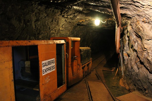
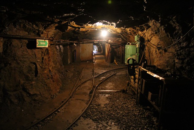
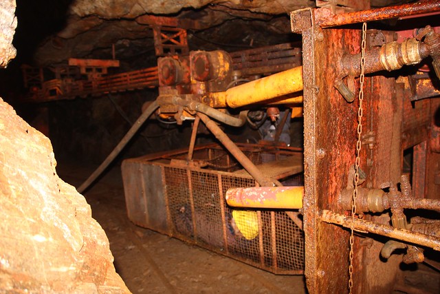
Saubergi kaevandus Saksamaal
Grube Sauberg, Ehrenfriedersdorf, Erzgebirge, Sachsen, Deutschland
Kaevanduses kaevandati tina- ja hõbedamaaki. Erinevatel andmetel alustati kaevandamist 200 kuni 750 aastat tagasi ja lõpetati 1990. aastal. Nüüd on kaevanduses muuseum.


Oil Shale mining-related research in Estonia
txt: Oil Shale, 2009, Vol. 26, No. 4, pp. 445–450 ISSN 0208-189X doi: 10.3176/oil.2009.4.01 © 2009 Estonian Academy Publishers EDITOR’S PAGE OIL SHALE MINING-RELATED RESEARCH IN ESTONIA Finally the long-announced changes arrived, caused by environmental, geological and technological changes in oil shale mining sector. In addition, the biggest change has occurred with alteration of professionals’ generation. In most of the countries, the institutions dealing with mining are facing difficult questions – to continue or not to continue, and if, then how. Research, development and teaching work are facing a low at the moment. The biggest section in oil shale business in which saving and effectiveness could be achieved is the mining sector. It includes social and environmental restrictions in deposits, losses in pillars and separation of products and waste rock. Losses are closely related to backfilling and waste rock usage. Much smaller sections include production of oil, electricity and chemicals in which most of the research and development is performed today. Efficiency of oil shale usage depends manly on mining technology. 446 Editor’s Page Current urgent topics for investigating, testing and developing of oil shale mining related questions are backfilling, mechanical extracting of shale and digital modelling of mining processes. Estonian oil shale mining industry with its 90 years of history has been a test polygon for equipment manufacturers, geologists and mining engineers from Germany, Soviet Union, Finland and Sweden. These are the reasons why Estonia has recently hosted in average one international mining-related conference per year and is going to host the most important and highest level of the conferences – Annual General Meeting of the Society of Mining Professors “Innovation in Mining” (SOMP AGM 2010, http://mi.ttu.ee/somp2010). Mining research concerning Estonian oil shale deposits Several mining-related factors, such as changes in environment, underground conditions, landscape and property, tend to awoke public resistance. In order to create sustainable mining conditions, research on the natural environment and experiments conducted in mines and mined areas are required. Together with physical experiments, computer modelling is a widespread method in mining engineering. The principal task of modelling is to choose criteria and constraints satisfying all involved parties, as well as ways of presenting. In reaction to this, various restrictions for mining (mainly environmental ones) are created. In most cases, their argumentation is onesided, often subjective. As a result, it is not possible to exploit a large part of deposits due to environmental restrictions, but also due to expiration of evaluation criteria of the supplies of resources. Part of the problems is caused by miners that do not apply environmentally friendly mining technologies. Mining environment is understood as the entity including resources (deposits and groundwater), land (agricultural and housing land), engineering and technology. Research has shown that ground and landscapes changed by mining can afterwards be of better quality than before. If reclaiming is planned skilfully, the soil, landforms, forest, water bodies and agricultural land can be more valuable than before mining. All this is the basis for developing acceptable, environmentally friendly mining. Acceptable mining requires engineering research concerning both natural and technogenic environment, e.g. modelling and pilot projects. As such research is voluminous, computer modelling has become the principal tool in solving problems related to all sorts of developments, technologies and effects. The key issue is defining criteria and restrictions that satisfy all the involved parties. Creating models and estimation criteria requires miningrelated expertise and a database acquired from measurements, experimenting and laboratory testing. Modelling is followed by laboratory and industrial experiments, which require profound know-how. The experiments include e.g. chronometry of technological productivity, geometric and geological measurements, and measurements of rock quality. The parties that compose mining plans, development plans and estimations of environmental effects Editor’s Page 447 have acquired planning and modelling software for various purposes, which causes some problems: the geological database requires skilful treatment; data exist in several geodetic coordinate systems and include partly obsolete stratigraphic terminology. Unfitting coordinate systems disturb the usage of cross-use of spatial data in various geoinformation databases (digital maps, border files, land registers, building registers, databases of technological networks of enterprises, etc.). This creates further problems related to mined areas. Most environmental restrictions, which have to be taken into account in mining and building, are not based on real measurements. Usually the restrictions are two-dimensional and do not take into account the structures of the geological environment. Such vagueness does not support precise engineering calculations or modelling. Basic modelling systems that are designed in developed mining countries are principally meant for deep deposits. However, in Estonia there are blanket deposits, which cause wider environmental effect of mining. Because of that, imported systems have to be adapted. Mining is possible in any circumstances, provided that sustainable mining environment has been created. In other words, with the proper choice of mining technology, the effect of mining has been damped below the level that the nature and man can tolerate. The methodology and criteria for planning, designing, modelling and accepting of sustainable mining environment will provide the basis for mineral raw material that the economy requires, both in the near and far future. The principal direction of developing mining technology is filling the mined area. This provides control over majority of environmental effects. For instance, filling the workings decreases the loss of resources and land subsidence, and at the same time provides usage for stockpiling. Filling the berms of surface mine decreases dewatering; harmless waste can be used for filling open mines and in this manner offer new building land. Local land subsidence related to mining may extend also to technological networks. It is possible to find out deformation parameters by geodetic monitoring. Taking these parameters into account enables to model further the extent and effect of the deformation. Modelling, including digital planning, is aimed at gaining and creating the following: mining indicators needed for making decisions, future scenarios of mining oil shale and building material, support for development planning at state and regional level, technological solutions that take into account all possible environmental effects and social reactions, new output: project solutions, theme maps, inquiries, zoning, evaluations of crises or risks, optimal methodology for gaining, storing and using information, having in mine requirements for various purposes and levels, more effective usage of geological, technological and spatial information, additional functionality of the database. The optimal solution is obtained by modelling. The most general but also dominant criteria are: minimal effect on man and nature, minimal amount of 448 Editor’s Page residual and waste, maximal economic profit, also in other fields not only in the mining industry. The problem includes several criteria, and its solving requires both theoretical and computational solutions. Principal methods are related to introducing sensors, measuring equipment and mining condition experiment, matching structures of various data and modelling based on them. The methods are: mapping the modelling criteria, indicators and processes of the mined areas; experimenting the possibilities of application, compatibility and results of mining software; applying laboratory experiments and fieldwork in modelling; creating models for blanket deposits (methodology in modelling MGIS, i.e. mining geoinformation system, models of new mines, changes in ground conditions, environment (modelling and analysis of groundwater dynamics, effects of dust, noise, etc.), geotechnological models in mined areas); applying seismological methods for developing theory for collapse risk, analysis methods for creating spatial models from geodetic spatial information, studies on material properties for developing theory for criteria for rock breakage, dendrochronologic studies for monitoring changes caused by collapses and changes in the water regime. As a result, conditions for creating mining environment satisfying all involved parties (industry, state, public, decision makers) will be developed, applicable for any deposit of any resource. A system of criteria of evaluating the mining environment will be designed. This research provides for mining science a new level of digital modelling of blanket deposits, basing on long-term experiments and modern digital planning. The research results will be applied in compilation of the state development plan, planning mined areas, as well as in teaching and science. The results are relevant principally for users of land and ground (builders, geologists, hydrogeologists, hydrologists, mining engineers and reclaimers). The results provide better understanding between the public and the miners, and further a basis for well-argumented communication and promotion for economy in the manner that satisfies both parties. In recent years, there has been a world-wide initiative for research, creating the concept of sustainable mining, using relevant indicators and making decisions based on them. MMSD (Mining, Minerals, and Sustainable Development), SDIMI (Sustainable Development Indicators for the Minerals Industry) and other international networks emphasize the need for creation of a concept for regional sustainable mining, relevant for local conditions. At the same time, modelling systems are being built and usage of non-traditional fuels is being started. About three decades ago oil-shale mines of the former USSR including Estonia did not use the progressive mining methods with continuous miner, which are most suitable for the case of high-strength limestone layers in oilshale bed. Therefore, oil shale mining with blasting has been used as a basic mining method in Estonian minefields up to now while continuous miner was tested for roadway driving only. As for cutting, the installed power of Editor’s Page 449 coal shearers and continuous miners has increased enormously since the original work. The actual state of the market has changed, and a wide range of powerful mining equipment from well-known manufacturers like DOSCO, EIMCO, EICKHOFF, etc. is available now. Estonia has 30 years of experience in cutting with longwall shearers which were not capable of cutting hardest limestone layer inside of the seam. Tests with road headers have been carried out in the 1970s. Additionally Wirtgen surface miners have been tested (SM2100 and SM2600) for two years as well as SM2200 and Man Tackraf surface miner, and currently the testing of Wirtgen surface miner SM2500 for high selective mining in an open cast mine is being performed. The main field to be developed in addition to mine backfilling is mechanical extraction of oil shale. Potentially this allows increasing oil yield, decreasing CO2 pollution, decreasing ash amount, decreasing oil shale losses, avoiding vibration caused by blasting, avoiding ground surface subsidence (in the case of longwall mining), increasing drifting and extracting productivity compared with current room and pillar mining, increasing safety of mining operations. The final aim of the research is to use BAT (best available technology) for underground mining in areas with arduous conditions of coal and oil-shale deposits. The main problems to be solved are: selective cutting of oil shale (15 MPa) and hard limestone (up to 100 MPa), roof support at the face, stability of the main roof, roof bolting, pillar parameters, backfilling with rock or residues (ash) from oil production, water stopping and pumping in problematic environment (30 m3 /t expected). Currently room and pillar mining with drill and blast technology is used underground. Supporting is done with bolts. Mining production is in total around 14 Mt/y, including 7 Mt/y underground. Total raw material amount underground is 12 Mt/y. Tests are made for opening new mines, with total production 15 Mt/y. Continuous miners keep playing a major role in the underground industry in over fourteen countries worldwide. Estonia’s oil-shale industry is at the beginning of introducing modern fully mechanized continuous miner systems, which could increase productivity and safety in the underground mines. A longitudinal cutting head-type miner was first introduced in the former Soviet Union by modifying the Hungarian F2 roadheaders and in the 1970s in Estonia by modifying the Russian coal roadheader 4PP-3. Evaluation of breakability was performed by a method developed by A. A. Skotchinsky Institute of Mining Engineering (St Petersburg, Russia). For this purpose over a hundred samples produced by cutting of oil shale and limestone, as well as taken in mines by mechanical cutting of oil shale were analysed. Evaluations were made for using coal-mining equipment for mining oil shale. Comparative evaluations were made by the experimental cutting of oil shale in both directions – along and across the bedding, including also mining-scale experiments with cutting heads rotating round horizontal 450 Editor’s Page (transverse heads) and vertical axes (longitudinal heads). In both cases the efficiency was estimated by power requirement for cutting. The feasibility was shown by breaking oil shale in direction of cutting across the bedding by using cutting drums on horizontal axis of rotation. The research also evidenced that the existing coal shearers proved low endurance for mining oil shale. Therefore, there arose the problem of developing special types of shearers for mining oil shale or modifying the existing coal shearers. It was further stated that the better pick penetration of the longitudinal machines allows excavation of harder strata at higher rates with lower pick consumption for an equivalent-sized transverse machine. It was reported that with the longitudinal cutting heads the dust forming per unit of time decreases due to smaller peripheral speed. The change in the magnitude of the resultant boom force reaction during a transition from arcing to lifting is relatively high for the transverse heads, depending on cutting head design. Specific energy for cutting across the bedding with longitudinal heads is 1.3–1.35 times lower which practically corresponds to the change of the factor of stratification. These are the questions waiting for answers in the near future for effective oil shale extraction in Estonia and in similar mining conditions. In spite of current economic problems, still everything begins with mining. Ingo VALGMA Head of Department of Mining of Tallinn University of Technology, Head of Estonian Mining Society, President of the Society of Mining Professors / Societät der Bergbaukunde
Oil Shale mining-related research in Estonia
txt: Oil Shale, 2009, Vol. 26, No. 4, pp. 445–450 ISSN 0208-189X
doi: 10.3176/oil.2009.4.01 © 2009 Estonian Academy Publishers
EDITOR’S PAGE
OIL SHALE MINING-RELATED RESEARCH
IN ESTONIA
Finally the long-announced changes
arrived, caused by environmental, geological
and technological changes in oil
shale mining sector. In addition, the
biggest change has occurred with
alteration of professionals’ generation.
In most of the countries, the institutions
dealing with mining are facing difficult
questions – to continue or not to
continue, and if, then how. Research,
development and teaching work are
facing a low at the moment.
The biggest section in oil shale business
in which saving and effectiveness
could be achieved is the mining sector.
It includes social and environmental
restrictions in deposits, losses in pillars and separation of products and waste
rock. Losses are closely related to backfilling and waste rock usage. Much
smaller sections include production of oil, electricity and chemicals in which
most of the research and development is performed today.
Efficiency of oil shale usage depends manly on mining technology.
446 Editor’s Page
Current urgent topics for investigating, testing and developing of oil shale
mining related questions are backfilling, mechanical extracting of shale and
digital modelling of mining processes.
Estonian oil shale mining industry with its 90 years of history has been a
test polygon for equipment manufacturers, geologists and mining engineers
from Germany, Soviet Union, Finland and Sweden.
These are the reasons why Estonia has recently hosted in average one
international mining-related conference per year and is going to host the
most important and highest level of the conferences – Annual General
Meeting of the Society of Mining Professors “Innovation in Mining” (SOMP
AGM 2010, http://mi.ttu.ee/somp2010).
Mining research concerning Estonian oil shale deposits
Several mining-related factors, such as changes in environment, underground
conditions, landscape and property, tend to awoke public resistance.
In order to create sustainable mining conditions, research on the natural
environment and experiments conducted in mines and mined areas are
required. Together with physical experiments, computer modelling is a widespread
method in mining engineering. The principal task of modelling is to
choose criteria and constraints satisfying all involved parties, as well as ways
of presenting. In reaction to this, various restrictions for mining (mainly
environmental ones) are created. In most cases, their argumentation is onesided,
often subjective. As a result, it is not possible to exploit a large part of
deposits due to environmental restrictions, but also due to expiration of evaluation
criteria of the supplies of resources. Part of the problems is caused by
miners that do not apply environmentally friendly mining technologies.
Mining environment is understood as the entity including resources
(deposits and groundwater), land (agricultural and housing land), engineering
and technology. Research has shown that ground and landscapes
changed by mining can afterwards be of better quality than before. If
reclaiming is planned skilfully, the soil, landforms, forest, water bodies and
agricultural land can be more valuable than before mining. All this is the
basis for developing acceptable, environmentally friendly mining.
Acceptable mining requires engineering research concerning both natural
and technogenic environment, e.g. modelling and pilot projects. As such
research is voluminous, computer modelling has become the principal tool in
solving problems related to all sorts of developments, technologies and
effects. The key issue is defining criteria and restrictions that satisfy all the
involved parties. Creating models and estimation criteria requires miningrelated
expertise and a database acquired from measurements, experimenting
and laboratory testing. Modelling is followed by laboratory and industrial
experiments, which require profound know-how. The experiments include
e.g. chronometry of technological productivity, geometric and geological
measurements, and measurements of rock quality. The parties that compose
mining plans, development plans and estimations of environmental effects
Editor’s Page 447
have acquired planning and modelling software for various purposes, which
causes some problems: the geological database requires skilful treatment;
data exist in several geodetic coordinate systems and include partly obsolete
stratigraphic terminology. Unfitting coordinate systems disturb the usage of
cross-use of spatial data in various geoinformation databases (digital maps,
border files, land registers, building registers, databases of technological
networks of enterprises, etc.). This creates further problems related to mined
areas. Most environmental restrictions, which have to be taken into account
in mining and building, are not based on real measurements. Usually the
restrictions are two-dimensional and do not take into account the structures
of the geological environment. Such vagueness does not support precise
engineering calculations or modelling. Basic modelling systems that are
designed in developed mining countries are principally meant for deep
deposits. However, in Estonia there are blanket deposits, which cause wider
environmental effect of mining. Because of that, imported systems have to
be adapted.
Mining is possible in any circumstances, provided that sustainable mining
environment has been created. In other words, with the proper choice of
mining technology, the effect of mining has been damped below the level
that the nature and man can tolerate. The methodology and criteria for
planning, designing, modelling and accepting of sustainable mining environment
will provide the basis for mineral raw material that the economy
requires, both in the near and far future.
The principal direction of developing mining technology is filling the
mined area. This provides control over majority of environmental effects.
For instance, filling the workings decreases the loss of resources and land
subsidence, and at the same time provides usage for stockpiling. Filling the
berms of surface mine decreases dewatering; harmless waste can be used for
filling open mines and in this manner offer new building land.
Local land subsidence related to mining may extend also to technological
networks. It is possible to find out deformation parameters by geodetic
monitoring. Taking these parameters into account enables to model further
the extent and effect of the deformation.
Modelling, including digital planning, is aimed at gaining and creating the
following: mining indicators needed for making decisions, future scenarios of
mining oil shale and building material, support for development planning at
state and regional level, technological solutions that take into account all
possible environmental effects and social reactions, new output: project solutions,
theme maps, inquiries, zoning, evaluations of crises or risks, optimal
methodology for gaining, storing and using information, having in mine
requirements for various purposes and levels, more effective usage of geological,
technological and spatial information, additional functionality of the
database.
The optimal solution is obtained by modelling. The most general but also
dominant criteria are: minimal effect on man and nature, minimal amount of
448 Editor’s Page
residual and waste, maximal economic profit, also in other fields not only in
the mining industry. The problem includes several criteria, and its solving
requires both theoretical and computational solutions. Principal methods are
related to introducing sensors, measuring equipment and mining condition
experiment, matching structures of various data and modelling based on
them. The methods are: mapping the modelling criteria, indicators and processes
of the mined areas; experimenting the possibilities of application,
compatibility and results of mining software; applying laboratory experiments
and fieldwork in modelling; creating models for blanket deposits
(methodology in modelling MGIS, i.e. mining geoinformation system,
models of new mines, changes in ground conditions, environment (modelling
and analysis of groundwater dynamics, effects of dust, noise, etc.),
geotechnological models in mined areas); applying seismological methods
for developing theory for collapse risk, analysis methods for creating spatial
models from geodetic spatial information, studies on material properties
for developing theory for criteria for rock breakage, dendrochronologic
studies for monitoring changes caused by collapses and changes in the water
regime.
As a result, conditions for creating mining environment satisfying all
involved parties (industry, state, public, decision makers) will be developed,
applicable for any deposit of any resource. A system of criteria of evaluating
the mining environment will be designed.
This research provides for mining science a new level of digital modelling
of blanket deposits, basing on long-term experiments and modern digital
planning. The research results will be applied in compilation of the state
development plan, planning mined areas, as well as in teaching and science.
The results are relevant principally for users of land and ground (builders,
geologists, hydrogeologists, hydrologists, mining engineers and reclaimers).
The results provide better understanding between the public and the
miners, and further a basis for well-argumented communication and promotion
for economy in the manner that satisfies both parties. In recent years,
there has been a world-wide initiative for research, creating the concept of
sustainable mining, using relevant indicators and making decisions based on
them. MMSD (Mining, Minerals, and Sustainable Development), SDIMI
(Sustainable Development Indicators for the Minerals Industry) and other
international networks emphasize the need for creation of a concept for
regional sustainable mining, relevant for local conditions. At the same time,
modelling systems are being built and usage of non-traditional fuels is being
started.
About three decades ago oil-shale mines of the former USSR including
Estonia did not use the progressive mining methods with continuous miner,
which are most suitable for the case of high-strength limestone layers in oilshale
bed. Therefore, oil shale mining with blasting has been used as a basic
mining method in Estonian minefields up to now while continuous miner
was tested for roadway driving only. As for cutting, the installed power of
Editor’s Page 449
coal shearers and continuous miners has increased enormously since the
original work. The actual state of the market has changed, and a wide range
of powerful mining equipment from well-known manufacturers like
DOSCO, EIMCO, EICKHOFF, etc. is available now. Estonia has 30 years
of experience in cutting with longwall shearers which were not capable of
cutting hardest limestone layer inside of the seam. Tests with road headers
have been carried out in the 1970s. Additionally Wirtgen surface miners
have been tested (SM2100 and SM2600) for two years as well as SM2200
and Man Tackraf surface miner, and currently the testing of Wirtgen surface
miner SM2500 for high selective mining in an open cast mine is being
performed.
The main field to be developed in addition to mine backfilling is
mechanical extraction of oil shale. Potentially this allows increasing oil
yield, decreasing CO2 pollution, decreasing ash amount, decreasing oil shale
losses, avoiding vibration caused by blasting, avoiding ground surface
subsidence (in the case of longwall mining), increasing drifting and extracting
productivity compared with current room and pillar mining, increasing
safety of mining operations. The final aim of the research is to use BAT
(best available technology) for underground mining in areas with arduous
conditions of coal and oil-shale deposits. The main problems to be solved
are: selective cutting of oil shale (15 MPa) and hard limestone (up to
100 MPa), roof support at the face, stability of the main roof, roof bolting,
pillar parameters, backfilling with rock or residues (ash) from oil production,
water stopping and pumping in problematic environment (30 m3
/t expected).
Currently room and pillar mining with drill and blast technology is used
underground. Supporting is done with bolts. Mining production is in total
around 14 Mt/y, including 7 Mt/y underground. Total raw material amount
underground is 12 Mt/y. Tests are made for opening new mines, with total
production 15 Mt/y.
Continuous miners keep playing a major role in the underground industry
in over fourteen countries worldwide. Estonia’s oil-shale industry is at the
beginning of introducing modern fully mechanized continuous miner
systems, which could increase productivity and safety in the underground
mines.
A longitudinal cutting head-type miner was first introduced in the former
Soviet Union by modifying the Hungarian F2 roadheaders and in the 1970s
in Estonia by modifying the Russian coal roadheader 4PP-3. Evaluation of
breakability was performed by a method developed by A. A. Skotchinsky
Institute of Mining Engineering (St Petersburg, Russia). For this purpose
over a hundred samples produced by cutting of oil shale and limestone, as
well as taken in mines by mechanical cutting of oil shale were analysed.
Evaluations were made for using coal-mining equipment for mining oil
shale. Comparative evaluations were made by the experimental cutting of oil
shale in both directions – along and across the bedding, including also
mining-scale experiments with cutting heads rotating round horizontal
450 Editor’s Page
(transverse heads) and vertical axes (longitudinal heads). In both cases the
efficiency was estimated by power requirement for cutting. The feasibility
was shown by breaking oil shale in direction of cutting across the bedding by
using cutting drums on horizontal axis of rotation. The research also
evidenced that the existing coal shearers proved low endurance for mining
oil shale. Therefore, there arose the problem of developing special types of
shearers for mining oil shale or modifying the existing coal shearers.
It was further stated that the better pick penetration of the longitudinal
machines allows excavation of harder strata at higher rates with lower pick
consumption for an equivalent-sized transverse machine. It was reported that
with the longitudinal cutting heads the dust forming per unit of time
decreases due to smaller peripheral speed. The change in the magnitude of
the resultant boom force reaction during a transition from arcing to lifting is
relatively high for the transverse heads, depending on cutting head design.
Specific energy for cutting across the bedding with longitudinal heads is
1.3–1.35 times lower which practically corresponds to the change of the
factor of stratification.
These are the questions waiting for answers in the near future for
effective oil shale extraction in Estonia and in similar mining conditions. In
spite of current economic problems, still everything begins with mining.
Ingo VALGMA
Head of Department of Mining of Tallinn University of Technology,
Head of Estonian Mining Society,
President of the Society of Mining Professors / Societät der Bergbaukunde
Artiklid
Artiklid
Dolokivi vee seest kaevandamine
Eesti artiklid
Eestikeelsed artiklid
Fosforiidi kaevandamise tehnoloogiad
Hämmastavad augud ja ökogigandid
Ingliskeelsed artiklid
Jalge all
Kaardistamine ja mäetööde plaanid
Kaevandamine ja keskkond
Kaevandamise mõju põhjavee tasemele
Kaevandatud alade kasutamine
Kaeveõõnte täitmine
Kust ja kuidas kaevandada?
Loodusblogi lingikogu
Maardu fosforiidilevila põhjavee kvaliteet
Maardu vee dünaamika
Maardu vee kvaliteet
Mäendus
Põlevkivi kaevandamise tehnoloogiate keskkonnamõju
Põlevkivi kaevandamisest tulenevate hüdrogeoloogiliste muutuste prognoos
Ruumimudelid mäenduses
Ubja põlevkivikarjääri ärastusvee päritolu
Vajumisalade kaardistamine
Varingud
Veeseire
Vesi allmaarajatistes
Ettekanded
Maa-alune maailm
Mäendus
Põlevkivi kaevandamise mõju Ida-Virumaa asumite kujunemisele
Papers
An evaluation of technological overburden thickness
Analysis of water removal parameters in mining sites
Computational groundwater monitoring and management system
Detection of Mine Collapses with Seismic Methods
Digitizing Mining Plans
Environmental impact of mining
Estonian oil shale resources calculated by GIS method
Explosives Handling
Geotechnical Processes and Soil-Water Movement with Transport of Pollutants
Influence of water discharging
Interpolation Techniques For Reserve Calculations
Low depth mining in Estonian oil shale deposit-Abbau von Ölschiefer in Estland
Map of oil shale mining history in Estonia I
Map of oil shale mining history in Estonia II
Mapping potential areas of ground subsidence in mining
Mine water and dewatering
Mine water as a potential source of energy
Mining Conditions for the Cement Industry
Mining influence on the environment
Mining influence on the water regime
Oil shale mining in Estonia and Russia
Oil Shale reserve calculations
Papers
Possibilities of mining under the mire
Post-stripping processes and the landscape of mined areas
Potential of underground minewater
Scholar
Sustainable phosphate rock mining
Technogenic water in closed mines
The future of oil shale mining
The impact of infiltration dam
The origin and amounts of removal water
Underwater blasting experiments
Usage of underground minewater
Vegetation restoration on opencast oil shale mines
Water Quality in Maardu Phosphate Rock Mining Area
IV

Tellimine:
Postitused (Atom)